Why conduct a survey?
Within the UK there is a limited amount of information on saltmarsh soil and vegetation communities. Yet, 24 % of the English coastline, 11 % of the Welsh coastline and 3 % of the Scottish coastline border onto a saltmarsh habitat. The more knowledge we can collect on this important frontline habitat the greater our understanding of its role in regulating climate change and coastal protection.
Currently, we do not know which salt marshes have which soil types, and our information on vegetation types is sometimes old, or only from some marshes. Your survey results provide us with a soil type and its associated vegetation community. This is very useful information and will be an invaluable addition to the limited data we hold on carbon stocks in UK saltmarsh soils. The survey results will be used by the scientists at Bangor University, and colleague researchers, to broaden our understanding of the links between soil carbon stock, soil type and vegetation community.
Many of us enjoy visiting and spending time on the coast. Scientists at Bangor University and the University of St Andrews are investigating what motivates us to spend time on the coast. You can provide an insight into why so many of us enjoy visiting and spending time on the coast.
Your surveys will support our ongoing research and management of natural coastal protection by salt marshes, and help us predict the resilience of marshes to environmental change.

Salt marshes are a natural defence against coastal erosion and flooding. We need data to manage them effectively.
How to survey?
The four plant community types that we would like you to do your survey in are usefully found in the mid to landward side of the marsh; they are less common at the seaward side of the marsh. Depending on what part of the country you are in you may not be able to find all four vegetation community types. For example, the Sea Purslane (Atriplex portulacoides) community is much more common on the east coast than the west coast of the UK.
As easy as 1-2-3
- Download the APP
- Create profile
- Submit survey
You have two options: a ‘short survey’ that takes approx. 5 minutes per sample or a ‘full survey’ that takes approx. 1 – 2.5 hours).
Quick survey (each sample takes approx. 5 minutes)
You will need
- Smartphone with ‘The Saltmarsh App’ loaded and GPS enabled
- Small trowel or garden ‘dibber’
What to do
- See if you can find one of the 4 predominant vegetation community types using the photos provided.
- Select it on the app and take a photo.
- With a small trowel or garden ‘dibber’ remove a small section of soil (approx. 5 by 5 cm area, 5 cm into the ground) from within the area of the vegetation type you have chosen.

Step 3: Taking a soil sample using a corer, but you can use a small trowel or garden ‘dibber’. You only need a small amount of soil.

The plant community types are likely to be found in the mid to landward side of the marsh.
- Use the soil selection part of the app to decide what type of soil you have and take a photo.
- Submit your result.
- Do not forget to replace the soil back in the hole you have made.
- If you would like to submit another survey result then pick a different vegetation community and start again!
More information
- Make sure you read the section on ‘survey safety‘.
- You do not need to dig a big hole to take a soil. sample
Full survey (approx. 1 – 2.5 hours)
You will need
- Smartphone with ‘The Saltmarsh App’ loaded and GPS enabled.
- Small trowel or garden ‘dibber’.
- 12 garden canes or other marker.
What to do
- Walk around the salt marsh and see if you can find all 4 predominant vegetation community types using the photos and descriptions provided. You should be able to find at least 2, but not all marshes will have 4.
- For each vegetation community type place a marker, pace out 10 large steps (approx. 10 m), place the second marker, then repeat until you have 3 markers in a row or ‘transect’ roughly 10 m apart.

Markers in a Common Saltmarsh Grass (Puccinellia maritima) vegetation community.

A transect is a line, here marked with a series of flags.
- Choose 1 vegetation type to start with and go to the first cane or marker.
- Select it on the app and take a photo.
- With a small trowel or garden ‘dibber’ remove a small section of soil (approx. 5 by 5 cm area, 5 cm into the ground) from within the area of the vegetation type you have chosen.
- Use the soil selection part of the app to decide what type of soil you have.
- Take a photo.
- Submit your result.
- Do not forget to replace the soil back in the hole you have made.
- Repeat for each marker for that vegetation type.
- Repeat for all other vegetation types.
More information
- Make sure you read the section on ‘survey safety‘.
- You do not need to dig a big hole to take a soil sample.
Survey safety
Once you have found the salt marsh you wish to visit and if applicable have been given permission from the land owner to access the marsh you need to consider your safety.
What to wear
Salt marshes even at low tide can be surprisingly wet places so make sure your footwear is waterproof. The weather on the coast can quickly deteriorate so always carry warm layers and a waterproof coat. When you collect soil samples you may end up kneeling on the ground, it is a good idea to wear waterproof trousers or use a kneeling mat. If it is a sunny day, do not forget a sun hat, sunscreen and water.

Collecting data in the winter and ready for the weather
Weather
Once you have picked the best day(s) to visit your salt marsh check the local weather forecast; make sure that you are appropriately dressed and carry enough food, water and spare clothes. Do not survey if fog is forecast.
5 day tide and weather forecast
Tides
Everyday there are two high and two low tides. These occur approx. every 6 hours. Tides vary in height depending on the phase of the moon; when the moon is full, tides will be at their highest and lowest (spring tides) and a when the moon is at first or third quarter, high tides are lower than average and low tides are higher than average (neap tides).You must never survey a salt marsh on an incoming tide, especially an incoming spring tide as you could get cut off; many salt marshes are interconnected by creeks that flood during high tide. Make sure you give yourself enough time to leave the salt marsh before nightfall.
Monthly tide times

Salt marshes are washed by the tides and are criss-crossed by creeks. Always check tide times before conducting a survey.
Working alone and in a group
If you do decide to visit a salt marsh by yourself let someone know where you are going and how long you expect to be.
If you plan to work in a group, make sure you have a group briefing so that everyone knows what they are surveying, how to survey and how long they have to collect data.

Always brief your group before starting to collect data.
Plan your trip
Find a salt marsh
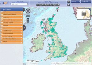
If you are not familiar with your local salt marsh then use MAGIC.
The MAGIC website provides authoritative geographic information about the natural environment presented in an interactive map.
To find your salt marsh:
- Click on ‘Habitats and Species’ in the ‘Table of Contents’.
- Expand the ‘Habitats’ menu.
- Expand the ‘Coastal’ menu.
- If you are in England click on ‘Priority Habitat Inventory – Coastal Saltmarsh’. If you are in Wales click on ‘ Saltmarsh’.
- The data layers for England and/or Wales will now be activated. You can adjust the transparency of the layers using the slide bar. This will allow you to see information underneath the selected layer.
- Using ‘Map Search’ search for your location.
- Once you have found a salt marsh that you would like to visit, view the salt marsh and surrounding area using ‘Map Scale 1:1,500 or 1:2,500‘.
- Explore the area and familiarise yourself with access routes. If you are not familiar with OS Map symbols then download the PDF https://www.ordnancesurvey.co.uk/docs/legends/25k-raster-legend.pdf
- Once you have identified your access route use the ‘Where am I?’ feature tool to find the post code, grid reference and co-ordinates of your location.
Please note: if the salt marsh is on private property it is your responsibility to contact the land owner and request permission to access their land.